| |
The Great Baikal Trail (GBT)
|
|

According to the description put forward by
Valentin Petrovich Bryanskiy----who himself, like Oleg Kirillovich,
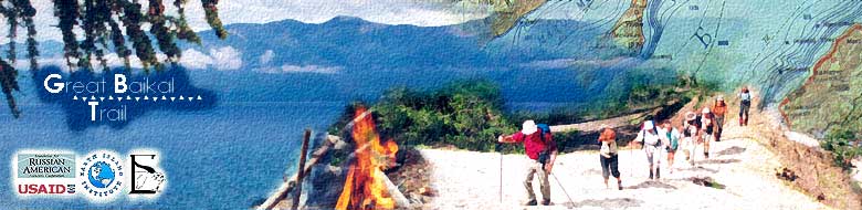
also walked around the lake----the trail will consist of 15 separate
segments. (See map.).
The first segment is to start in Kultuk, on Cape
Shamanka, which many consider as the best starting point. Traditionally
one has to start by walking clockwise, as local shamans always
do. This first segment of the GBT is also called the RBRR (short
for Round-Baikal Rail Road). As part of this project, informational
materials about the RBRR will be distributed not only in Slyudyanka,
but also in the trains that travel along the Trans-Siberian Railway
(at least in the non-local trains). The same materials will be
sold in Listvyanka. Local people also will be able to sell souvenirs
to travelers along the RBRR. Another good place for selling souvenirs
is the ferry-boat that carries passengers from Port Baikal across
the mouth of the Angara to Listvyanka. Tourists probably would
love to buy scads T-shirts with pictures of tunnels and trains
at Baikal.
This trail segment # 1, as one of the most accessible
areas of Baikal, would be amply maintained.
Visitors would be asked to pay a reasonable fee to use the trail
(10 rubles per day, for example, or approximately $0.33). This
money would go for creating and maintaining trail infrastructure,
and pay for clean-up of the trails. Informational materials would
include data on places where campers could buy firewood and propane
canisters.
Trail segment # 2 would start in Listvyanka.
Here the setting is quite different. There are even plans to build
a popular skiing resort here. Even now, this village is the most
visited place on Baikal. (Note: There's a rumor that there will
be comfortable restrooms soon along this trail.)
This segment has a lot of sightseeing potential.
In contrast to the RBBR, which runs along an old railroad, the
Listvyanka trail is more natural; it will still require very good
management and service, because of the large amount of people
who are wanting to visit the site. The distance form Listvyanka
to Bolshoye Goloustnoye is 60 km (38 miles). On the way to Bolshoye
Goloustnoye there is the village of Bolshie Koty (or Big Cats).
At Kadilnaya one comes again on the border of Pribaikalskiy National
Park, and soon thereafter, there is Skriper Mountain. Those who
want to work and earn money by serving tourists on this segment
of the trail can easily choose an attractive site to "symbolize"
this trail segment, such as the famous Shaman Rock at the mouth
of the Angara riverhead, or Devil's Bridge further north.
The distance north between Goloustnoye and Buguldeika
is some 86 km (53 miles). One of the major tourist attractions
on this part of the trail is Peschannaya Bay, which lies in the
middle of this trail segment. This site actually gives its name
to trail segment # 3 - "Peschankinskaya". This beautiful bay is
a very popular visiting site, esp. among Irkutsk city-folk. Because
of its easy accessibility to city dwellers, this site has become
significantly degraded during last 25-30 years. Creating a manageable
trail should help to preserve this, one of the most beautiful
parts of Baikal's shores.
Trail segment # 4, the "Tazheranskaya", is a
112 km (70 mile) segment north of Buguldeika. Here the Aya Bay
is famous for its ancient rock paintings (which, for the business-minded,
could be copied for T-shirts and other souvenirs). The Tazheran
Steppe, and the many caves on the shore, as well as Erdo Mountain
where traditional Buryat Games are now being conducted again,
are all waiting to be rediscovered by tourists. This segment,
then, is a real "depository" of legendary sites and Buryat myths.
Trail segment # 5 is called "Malomorskaya" (or
"Small Sea" trail), and is a 128 km (80 mile) stretch leading
to Onguren. The Small Sea is a wonderful place for fishing---tourists
would never starve along this segment of the trail. The famed
Omul-fish could easily become the symbolic attraction for this
segment (but then again, so could the famous Sarma winds here).
Trail segment # 6 has the beautiful name of "Brown
Bear Shore", and runs for 141 km (90 miles) from Onguren to Cape
Yelokhin. This name once was going to be used for the Baikal-Lenskiy
Nature Preserve, which is located along this shore. It seems obvious
that Brown Bear should symbolize this segment. No one can go here
without the special permission from the administration of the
Baikal-Lenskiy Nature Preserve.
(Note: Administrations of Baikal's 3 nature preserves
will decide for themselves how many (if any) tourists they want
to allow on the trail at any one time. Obviously, in June, during
the bear season on Baikal's shores, all visits must be curtailed.
The only exception will be for those who do work for the nature
preserve. In any case, all tourists will have to note that this
segment is restricted in access. The Reserves also have the option
of setting up relatively higher fees for passing along this segment,
which could also help to restrict amount of visitors. In any case,
the precautionary principle of not harming nature should be the
priority for this trail.)
Besides the image of Brown Bear, souvenirs could
have images of the Lena River. The Lena River is the largest Siberian
river, and has its headwaters behind the mountains here, near
the weather station. There is already a good trail leading to
the Lena's source. (Note for international visitors: the first
leader of the Soviet Union, V.I. Lenin, adopted his last name
from the years that he spent in exile during tsarist times along
the Lena River.)
Next is the "Goryachiy Bereg" (or Hot Springs
Shoreline), which is a 124 km (77 mile) trail segment. It is situated
between Cape Yelokhin and Cape Ludar. Along the way there is also
Cape Kotelnikovskiy, many hot springs, and renowned Cherskiy Mountain
(some 2,588 meters in elevation).
Trail segment # 8 - the "Severobaikalskaya" (or Northern
Baikal) route, is 118 km (73 miles) long. Here one comes across
the BAM (Baikal-Amur Rail Road), as well as the Ornithological
Game Reserve named "Verkhniy Angarskiy". Also there is the 15
km long island called "Yarki", along with the town of Severobaikalsk.
The symbols for this trail segment could be the numerous bird
species found in the game reserve, or the archeological monuments
dating to the Kurykan era.
Trail segment # 9 starts at the Dagarskaya Inlet. This
is one of the most interesting and inaccessible parts of the GBT.
Here are Frolikha Lake, with its endemic fish Davatchan, along
with the distinctive rocks at Cape Khaman-Kit, and the hot springs
at Khakusy. The length of this part of the trail is 91 km (55
miles).
Trail segment # 10 is called "The Trail of the Old Evenk",
and it seems that no other name could be assigned to this segment.
This 112 km (69-mile) segment starts at the Tompuda
River, next to the weather station there. (Note: the household
of the Evenk family Rogovy could easily become an informational
center for this part of the trail, because they already host many
tourists to these parts.) It is not difficult to find any number
of symbols for this trail. It could be the native Evenk in his
or her national costume, or the Northern deer, or the traditional
Evenks ornaments. Here, by the way, is the highest mountain at
Baikal (Baikal Peak - some 2,841 meters high), although it is
quite far from the shore.
The next 79 km (50 mile) portion of the trail,
now # 11, is called "Sobolinaya "(or Sable). It starts is Davsha
and ends in Bolshoi Chivyrkuy. The trail travels through part
of a nature preserve, and thus, visiting this site requires permission
from the Barguzin Preserve administration in Nizhniy Angarsk or
Ulan-Ude. (In other words, similar to the Brown Bear shore, this
part also has restricted access. Those who are planning to pass
along this trail should note that they would have to negotiate
their visit with the administration of the nature preserve. Not
everyone will have the privilege to wear the T-shirt with a picture
of sable, claiming to have traversed this part of the GBT.)
It would be unfair to overlook the word "Barguzin";
that is why 206 km (125 mile) trail from Bolshoi Chivyrkuy to
the village of Maximikha is called "Barguzinskaya". So much is
named the same here: there are the Barguzinskiy Mountains , Barguzinskiy
Bay, not to mention the Barguzin wind that blows from the Barguzin
River basin here. It should not be forgotten that Bargudjin-Toku
was the homeland of Oilun-Ehe, Genghis-Khan's mother. It is also
the site of such attractive landscapes at the Svyatoi Nos (or
Holy Nose) Peninsula, which juts out into the center of Baikal.
Trail segment # 13 has two names, "Tropa Davidova" (Davidoff trail)
or the "Enchanted Shore"; it is 216 km (130 miles) long, ending
in the village of Dubinino. The highest point on this segment
is Davidoff Mountain (1,717m). There are many large caves here,
some of which may not have been explored yet. In the beginning
of June, a yellow carpet of water lilies covers the Selenga River
Delta here.
The longest and the most populated segment of
the GBT is called the "Khamar-Dabanskiy", and is 289 km (177 miles)
long, starting in the Selenga Delta. Here there is the Posolskiy
Monastery, built in the middle of the 16th century. The Trans
Siberian Railroad, the longest railroad in the world, stretches
along this segment. Those who travel from Moscow to Vladivostok
know that this part of the trail is the most popular among travelers.
Some of them pass by Baikal once in their lifetime, and likely
would want to buy a souvenir that would remind them about the
place. There is the Baikal Nature Preserve here. Also there is
a very beautiful natural system of warm lakes near the Snezhnaya
River (or Snowy River). The symmetrical image of the "Shapka Monomakha"
Mountain could be placed on T-shirts as well. The money gained
from selling souvenirs could be used for maintenance and restoration
of these beautiful places, which are now damaged by too many tourists.
The trail circuit around all of Baikal is completed
now; but our travel on the GBT is not yet finished.
|