 |
|
|
Related links:
If you are going to make a visit to Siberia, you found the right place to start your journey!
ABOUT US
FACTS ABOUT BAIKAL
THE BURYAT REPUBLIC
PLACES TO VISIT
BED&BREAKFAST
TOURS!
PHOTOGRAPHY
CONTACT US
GUESTBOOK
Subscribe for news of this site!
 |
Buy at amazon.com Trans-Siberian Handbook by Bryn Thomas

This new edition of the guide to the world's longest rail journey is packed with practical information on planning the trip and booking tickets. Background information is also included on Siberia's infamous past and the history of the railway. 30 color photos
|
 |
| |
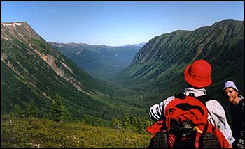
The valley of Zhoigan.
|
Brief description of the area
|
Okinsky region, or shorter Oka, is one of seventeen counties of Buryat republic. It is the most remoted part of Buryatia, situated to the West of capitol city Ulan-Ude on the range about 600 km. Previous time it was populated by Soyots - a turk language tribe, which now is assimilated with Buryats, main nation of this part of Siberia. Buryats - one of the big nothern Mongolian tribes, which became a part of Russia more than three hundred years ago. The whole population of Oka is about 5000 people, though the territory is rather big and makes 44 thousand square kilometers.
|
|
The region is characterized by tipical alpine rugged landscape with rocky summits and deep narrow valleys, mountain passes mostly are flat plateaus, swampy in summer because of permafrost, which melts in warm season. The streams are fast and cristally clear, as there are no industrial objects. The main and the biggest stream of the area Oka river is perfect for rafting. General occupation of indigenous people is hoursekeeping, cow and sheepherding. Oka is the only region, where people still keep yaks, which are becoming rather rare animals. In winter time men go for hunting, for the area is wellknown as abundant with wildlife. Trails inside the county usually made by hourses and yaks and go along valleys thru every mountain saddle.
Since the most remoted from industrial and cultural centers, local people kept more features of traditional way of life and culture. Oka is the wildest and the least experienced by western adventureres district of Buryatia. Yet it is the very heart of Eastern Sayan mountain country - the clearest, the purest and unforgetably beautiful. The main belief of locals is shamanism, or animalism, mixed with lamaism, which actually is a branch of Buddhism. The administrative center of Oka is Orlik, a small town with population more than a thousand, which is constantly growing, as many young pairs move there from other districts.
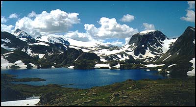
Big Sayan range.
|
The main way to the region connects Oka with Sludyanka - big railway station of Transsiberian on the shore of Baikal lake. The distance from Sludyanka to Irkutsk, the biggest East-Siberian city with international airport and railroad station is 90 km only.
In general the whole area is perfect for all kinds of adventure travels - trekking, rafting, mountaineering, backpacking and winter ski tours. The climate is sharply continental, with long cold winters with deep snow and short hot summers. Average temperature in January 20 degrees below 0 (Celcium), in July 18 degrees above 0.

Waterfords are many on the way. Sometimes we do it horsebacking.
|
Here below is a trekking route suggested for adventureres by Siberian Guides,Inc (a member of Center of Adventure Travel and Federation of Alpinism and Sport Tourism of Buryat Republic).
Day 1. Arrival to Irkutsk. Hotel accomodation. Currency exchange, postal services. City tour. Lunch can be taken in a cafe during city tour, dinner can be served in a restaurant.
Day 2. Taken by truckbus to Orlik. On the way a lot of interesting sites as tipical Siberian and Buryat villages, sacred places for local spirits of nature called "burkhan" and "obo". Lunch in cafe with local food. Great nature scenary along the road, including impressive site of Munku-Sardyk Mount ( in Buryat "Eternal Mount")- the highest summit of Eastern Siberia (3491 m).Overnight in Orlik or Sayany village in local family.
Day 3. Sayany village - Dodo-Khutyl creek - Olon-Nur lakes.
Drive on a truck to Dodo-Khutyl creek via Shasnur settlement. In Shasnur the lugguage can be loaded on hourses. The trail to Olon-Nur lakes goes through the pass which is actually a plateau, the slope is not steep, the trail is rather easy. Campsite on the shore is a nice place to spend a night.
Day 4. Olon-Nur lakes - Boursag creek.
Hike upstream Khakta river along the edge of ancient lava field. The trail is easy, lunch can be taken on a nice spot on the bank. Overnight near an old wooden hoursekeepers' cabin (local "letnik") on a big meadow.
Day 5. Boursag creek - Sagan-Shuluta (in Buryat "White Rock") cabin.
On the way we'll pass picturesque Boursagay-Nur lake and cross ancient lava field. The trail thru lava is marked by stonemen. Bushwacking to the cabin on the bank.
Day 6. Sagan-Shuluta - the pass to Volcano Valley.
Waterford upstream (bathshoes needed). Hiking along yak trail to the pass. The trail is swampy in some places.The great scenery from the pass on both sides. In the valley two ancient volcanoes, named after Russian scientists Kropotkin and Peretolchin, surrounded by large lava field.
Day 7. Volcano Valley - the plateau pass - Khoyto-Gol Warm springs.
The trail leads from dead ancient lava fields to the plateau, passing on the way a beautiful lake under the pass. The altitude of the pass is 2750 m above ocean level. The unbelieveably beautiful panorama stretches to the horizon, from there one can see all the rugged area up to Big Sayan range with Topographov Peak (3044 m). The trail on the plateau is swampy enough because of permafrost. Good warm baths in Khoyto-Gol. Nice spot to have good rest after hard walking. Overnight may be both in tents or cabins.
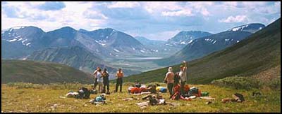
The view to Volcan valley.
|
Day 8. Khoyto-Gol sojourn.
Day 9. Khoyto-Gol - the pass - Dunda-Gol cabin.
The trail is easy and goes through taiga forest. Gradually the astonishing view of snow-capped range rolls out over. Alpine meadows with wonderful mountain flowers on the way. Lunch should be taken in the circ near a lake - it's a picturesque place and it's worth to stay there for a while. Marvelous view of Big sayan Range. Overnight on the lawn near the cabin.
Day 10. Dunda-Gol - Tchoygan Hot Springs.
Tchoygan (in Tuvenian means "fur tree") is a sacred place for both Buryats and Tuvenians which lies near the border of Tuva (or Tannu Tuva), neighbour republic to Buryatia. Tuvenians have their own culture and language which is turk. The spot is famous for natural mineral hot and cold springs.
Day 11. Tchoygan Springs - Peak Topographov - campsite.
This part of the route is more difficult, the trail is not easy, on the way stunnable views of waterfalls and green lakes. Trekking up the trail we pass a big glacier of Peak Topographov. Overnight in tents on campsite behind the ridge near the lake.
Day 11. Elevation Peak Topographov.
Day 12. Campsite Topographov - Dargyl creek - Khoyto-Gol.
Hike down along Dargyl creek to the junction of three streams and back to Khoyto-Gol.
Day 13. Khoyto-Gol - Khalun-Ukhan - Sayany village-Orlik.
An easy walk down a truck trail to Khalun-Ukhan cabin. A nice place with a big lawn in the bank of the stream, with a hot spring near the rocks. Driven by truck to Sayany.
Day 14. Orlik - Sludyanka - Irkytsk.
Taken by a truckbus to Sludyanka and then to Irkutsk. The lust supper in restaurant or cafe. Accomodation in a hotel.
Day 15. An excursion ride to Listvenichnoe on the shore of Baikal. Lunch can be served in restaurant of Intourist company with nice Siberian dishes and local beverages. Departure.
|